Tuesday, August 31, 2010

Wequiock Falls - (New) Home of the Legendary Jean Nicolet Statue

Wequiock Falls
Hello fellow travelers and seekers of the less beaten path.  The Internet while replete with all sorts of bits and pieces of a particular interesting place, landmark, wayside, etc. can take an average person a lot of concentrated surfing to pull it all together. That's where THIS blog differs; if I find it interesting, I'll pull it all together for you...right here.  Together, we're also bound to discover more of what lies behind and under the surface story too.  Kinda' like most people do a "drive-by" on their lives and never really see or understand the whole picture...either too busy or too distracted.  We won't let that happen to us...no siree.
 
It's now time for my second installation of this new blog.  I thought it prudent to explain more of what this vehicle is truly about before I get too far along the journey.  Obviously it is about me and what I think is interesting in the way of roadside attractions and curiosities, however it is also about you the reader and what you could possibly take from each vignette to enrich your own brief existence here on planet earth.  In regard to the former; if something catches my attention, I find it necessary to investigate and to ultimately report via this medium.  It's just that damn near everything catches my attention lately...where to start, where to start? 

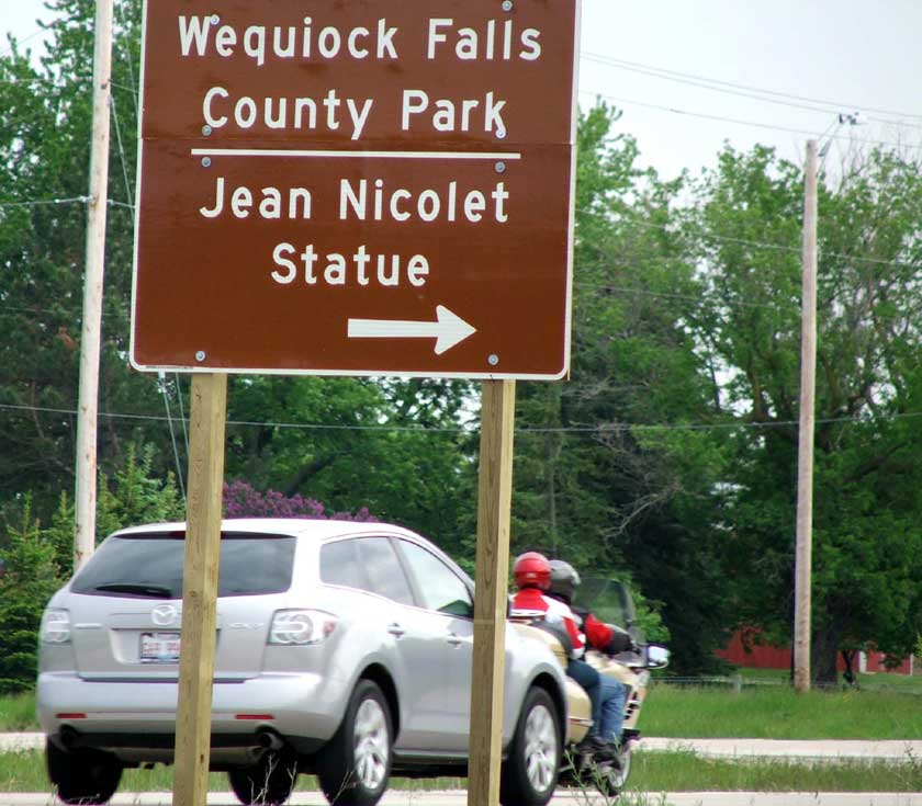
How about a recent spring trip to Door County, WI where the thing that I spied was the same thing I have seen on multiple trips up north...let's try that.  It all began with a hwy sign.  The sign interestingly beckoned, "Wequiock Falls County Park - Jean Nicolet Statue".  Now, the problem with that sign over the years of my seeing it was that it seemed to point to nothing, and to nowhere accessible; least ways from hwy 57 N. (at 65 MPH) did it point to nowhere accessible.  That and the fact that I was always "with" people who would in no way want to delay their trip to "The Door" by any more than a potty stop and some auto fuel.  This time however, I was by myself and looking to (finally) investigate the mystery.  Now I could have sworn that there was no way in hell to actually get to the statue because in all the years I had driven this route, I spotted no road access, however THIS time it looked easy as pie...why?  (I'd find out later that the statue was moved recently {in July of 2009} to this more accessible spot next to Wequiock Falls, narrowly edging out the Bay Shore Park as a contender because of proximity historical significance to his actual theorized landing spot)   In short; the new highway 57 completed in 2005 had cut off access to Jean and that was unfortunate.  It took the tenacity of Brown County Parks and Recreation Assistant Parks Director, Doug Hartman almost 3 years to shepherd the move.  This decision to keep the statue in the Town of Scott (where it had been since 1942) seemed to make the locals happy.  Timberline Landscapes in Scott was ultimately paid 40K to move it.  So, with my new motto of "life's too short...why not?" urging me onward, I pulled off Sturgeon Bay Rd (Hwy 57) onto Van Laanen Rd and followed the sign to the first parking area that looked likely to have my answer.

 
A small knot of young people were having a cookout at one of the permanent grills.  The two post-high school boys and one youngish looking girl were throwing a Frisbee back and forth, while holding what appeared to be adult beverages, as large black dog romped back and forth between them.  Not wanting to disturb this unbalanced pastoral scene with my sudden appearance (and camera) I turned the WPT around on the gravel and drove back out onto the road.  Heck, I didn't even see a "falls" anyway; let alone Jean Nicolet.  I turned right on Van Laanen and thought about finding 57 again when within 500 feet I spotted another sign and a large bronze statue in a clearing. 

 
The gravel parking area was just adjacent to a small path that lead to a bronze plaque embedded out front of the statue proper that read, "A gift to Wisconsin by her school children 1939-1940 during the tenure of John Calahan State Superintendent of Public Instruction".  The statue, erected in 1942, was the brainchild of local school principal Robert Desereau. School kids in the 1930s and 40s pitched in pennies, nickels and dimes. Next to the statue in the grass; a familiar template of the typical routered brown and white State of Wisconsin Historical Marker (complete with routered badger at the top) sign told the story of this particular monument\'s significance. 
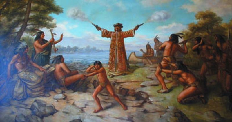
 
Basically, explorer Jean Nicolet (Zhan "Nick-o-LAY" here in Wisconsin...but if you are in Minneapolis it's "NIK-oll-ET") de Belleborne emissary of Gov. Samuel de Champlain of New France was looking for the "Orient" in 1634 when he took a slightly wrong turn and ended up at (Red Banks) near Green Bay, WI. (an easy mistake I myself have made).  He and his entourage then exited his fleet to greet the Chinese locals; Jean in his long flowing oriental overcoat, took out his pistols from behind his gaudy cape and FIRED them for effect.  That unexpected maneuver really seemed to impress the band of Winnebago Indians who had come down to investigate, as they immediately treated him as a man of power; an ambassador and asked him to share an impressive feast in his honor where they butchered "six score" beavers.  (That's about 120 of the little buck-toothed critters in case you wondered...DAM that's a lot of busy little flat-tailed creatures for an evening meal!)

 
Then dear reader, there's the aforementioned falls of Wequiock to discuss.  It seems that the planners of the more recent resting place of Mr. Nicolet knew what they were doing when they set him down here.  All one needs to do is walk a 100 feet south and the top of the twenty five foot falls is right there under a foot bridge to the wayside park I first had driven to.  The actual address of the falls is 3426 Bay Settlement Road in the Town of Scott.  If you are into waymarking; the coordinates are: N 44° 34.109 W 087° 52.768 - 16T E 430166 N 4935392.
 
Wequiock falls (a "curtain" type waterfall) is the result of the Wequiock Creek tumbling over the Niagara escarpment (more accurately the Silurian escarpment).  It is documented to be far more impressive in the early spring as you might imagine with the natural snow melt up the creek.  The later spring day I witnessed it; it was not quite a torrent, but rather respectable as Great Lakes waterfalls go.  If you would like to peruse the UWSP geology descriptions of the actual rocks that make up the falls; look HERENo-Doze Alert: If you are brave enough to visit that link, you're likely to also learn all about the Maquoketa Formation too.  Frankly how the rock enthusiasts know what they know is beyond me; and for all I know it could be all made up, but it is surely fascinating in a heady sort of way.  Not to mention getting to use the word "Imbricated" in a sentence...that's priceless.

 
The foliage had grown up in the basin and the sun had warmed the air quite nicely as I descended the sturdy manufactured set of wooden stairs to the base of the creek.  These stairs are amazingly well built and are probably the nicest set of landmark stairs I have even been on...no kidding.  I was impressed and remain so to this day.  Whatever Brown County paid to have them constructed was money well spent.  I took a slow and careful walk to the bottom of the falls and breathed in the moist air...ahhh...that's nice.  Plus, who doesn't like the sound of the rushing water?  If they say they don't, they're lying...so THERE!

 
All Things Wequiock
  1. Wequiock = Means "bladder" from the Ojibwe word "wikkway".  [Source: Milwaukee Sentinel, Aug. 29, 1939.]  So if you gotta' "go" your Wequiock is full I guess.
  2. Here's Wequiock Falls in the winter on YouTube
  3. Here's the falls on a PBS television station called WETA. 
  4. There's even a Wequiock Elementary School in Green Bay, WI  (Bladder Elementary School eh?  Their mascot could be something like one of those red rubber hot water bottles your grandma used for an earache, however the savvy Wequiockians have chosen the "pandas" of course.  The PC crowd probably thought that the name meant an actual Indian's name like "Cheif Wequiock of the Full Bladder Tribe", so they erred on the side of caution with that one...good thing too I guess.
  5. Map and Map of Wequiock, WI (Really?  Map Quest seems to think there's an entire "Town of Wequiock")
  6. So does the US Gazetteer.
Anyway, enough of that insanity...the Internet is a zany madcap place indeed; so don't believe it unless you read about it here on the Roads Less Traveled blog.  Visit the park, falls and statue on your next trip to The Door...you'll like it and you'll know the WHOLE story even before you do.

Have a great journey on any road you have not been down before...and I'll see you later.

Fantastic construction eh?
From the bridge looking toward the walkway

Sunday, August 22, 2010

Oak Hill...The Freeway Onramp Cemetery - Wauwatosa, WI

Oak Hill (off Capitol Dr.)

It’s been an unusually hot and humid summer - especially for Milwaukee Wisconsin. Don’t get me wrong…I like the warmth much better than the cold. However, human nature is to complain regardless of the weather. I guess the reason I notice it (and mention it) is my current self-imposed living arrangement. You see, I left my wife of nearly 26 years; the love having all but evaporated like one of those cone-shaped room air fresheners that you have to open up to expose the soft inner core - and moved into an upper half of a house with zero AC. Since the place I’m renting didn’t come with it, and I would have to pay for it…I’m suddenly uber-frugal with my meager stipend. I can also unequivocally attest to you dear reader that heat does indeed rise…I have the sweat-stained tee shirts to prove it. I guess that’s one reason I totally enjoy getting out in the deep woods…the coolness of natural shade.


No there's really no giant Red Arrow in the sky
Even at 8:30 AM on this particular Sunday; the Cicadas were buzzing with gusto as I parked the White Pickup Truck under the westbound bridge of Milwaukee’s Capitol Drive. Why not park the vehicle in the shade I thought, as I gathered up my binoculars, tripod and camera. I knew I’d be away from it for a time and didn’t need to come back to an Easy Bake Oven interior. My goal for today was two-fold; investigate the crumbling and forlorn cemetery plots directly adjacent to the Capitol Drive highway 45 North freeway onramp, and to walk the trails that lead away into the woods near the graveyard ruins.

The only convenient access, was to park where I did and walk a short distance - so walk I did.  Note: The focus of THIS particular blog installment will be the cemetery, if you want the “trail” segment (because it is more birdy in nature)…look HERE within the (wildly popular) Birdstud Blog.


I must have driven past the markers over 100 times in the 22 years living in Milwaukee. Each and every time in the past 3 years however, I vowed to find a way to investigate them more fully. I’d pull up to the stop sign glance to my right, spot the curious cemetery plots so out of place, and continue turning right onto the freeway ramp thinking: I need to check that out someday. Well today was someday and now I was approaching the oddity from the east on foot along the busy roadway. My first impression was that someone, somewhere, somehow must have been making a miniscule effort to maintain the property, as I could see a chain across two posts with Lannon stone curved retaining walls that somehow indicated an entrance. The grass near this opening was lower as if the highway department might have been recently through with its massive mower deck whirring and chopping away. A tall flag pole with flag adorned the left side near what appeared to be military style grave markers.

I observed two signs at the front of the cemetery. One white plywood sign, hand painted with black letters that read,” Oak Hill Cemetery – 1853 – This acre was purchased from Mr. Clarke Brookins by the Oak Hill Burying Ground Association. Burials began in 1839. Civil War Vets Johann Bahler and Dr. Levi Halstead are buried here with other Wauwatosa pioneers.” And another newer more “county-looking” routered one that read simply, “Oak Hill Cemetery – Est’d 1854 Wauwatosa” that was no doubt brief in nature so that moving cars had a chance to know just what this unique area harbored. So hmmm…technically the(suburb) City of Wauwatosa land eh?


I don’t know if you are a history buff or a person who likes antiques – a cemetery enthusiast or are merely curious about “old stuff” like I am, however I found this place compellingly interesting and quietly stimulating. Sure, I could visit, walk around swatting the mosquitoes that hung to the tall unkempt grass, looking at what was left of the markers, but to really know what this place was all about…research would be necessary. I just love that part.


The Milwaukee County Online Genealogy and Family History Library states that from an article published in the Wauwatosa News Times June 25, 1887: "Oak Hill became a burial ground in 1853 after Clark Brookins sold one of his 150(?) acres of land to the newly formed Oak Hill Burying Association. He charged $20 for the parcel and plots were sold for $1 each. The oldest grave belongs to Julia Knapp, who died in 1848. Although the area officially became a cemetery in 1853, farmers buried relatives there before that, which was the reason Brookins sold off the property." The cemetery records were destroyed in a fire in 1912. “The tiny, 1 acre glade, provinces the resting place to the gentleman farmers of early Wauwatosa." There farmers were mostly German immigrants.


The transcriptions below are from a book by Elizabeth Dohrety Herzfeld. I personally have highlighted the few of the 83 family names that I photographed, however the entire “roster” is located HERE.  Just an FYI for any of you who wish to be remembered longer than others; buy that reddish granite looking headstone - they seem endure and remain far more legible than your run-of-the-mill stone marker…think about it.

Key - OSSW = ON THE SAME STONE
Halstead / Bahler


BAHLER:


Johann/b. 1843/d. 1880/Pvt Co. 1 17 Wis Inf US on star marker/NEXT TO:


Johann/b. 1813 (??)/d. 1880/probably wrong birth date


Beggs


BEGGS:


Daniel/b. 1856/d. 1820/father/OSSW:


Emma/b. 1858/d. 1928/mother


Bell


BELL:


Francis/b. 18 Nov 1816 Co. Tyrone, Ireland/d. 5 May 1911/seems to be 7 stones


in Plot/Mary Ann, Frank, Charles/3 mothers/1 father


Glass


GLASS:


Lizzie/b. 1858/d. 1939/OSSW:


Luther/b. 1865/d. 1846


Gruenwald


GRUENWALD:


Charles/b. 20 Oct 1811/d. 2 Jun 1860/dates could be wrong


Henrietta/b. 1836/d. 1923/Mother/NEXT TO:


Wm./b. 1836/d. 1919


Halstead's Little Red Store

HALSTEAD:


Dr. L. C. (Levi)/b. 1817/d. 12 Dec 1902/Surgeon 7 Wis Vol Batry Lt. Arty/age 84


years 8 months/US on star marker/NEXT TO: (HALSTED)


The oldest commercial building in Wauwatosa, WI -The Little Red Store - 7720 Harwood Ave was built in 1854 by Dr. Levi Halsted Wauwatosa’s 2nd physician in 1848, in the center of the village at the intersection of the Plank Road, the Menomonee River and the railroad. It was originally intended to be a blacksmith shop but instead became the private dwelling for Dr. Halsted. Since then, the Little Red Store has served many purposes. It was the first railroad depot in Wauwatosa and is the oldest post office building in Milwaukee County still standing. It has also served as a general store, grocery store, harness shop, plumbing shop, library and Republican Party headquarters. It served as the community’s first railroad depot and express office, and it remains the oldest standing post office building in Milwaukee County. The Little Red Store was designated a city landmark by the Wauwatosa Landmark Commission in 1978 and a historic structure under the city’s historic preservation ordinance in 1998. The property is designated for its historic significance in 2008


Klinger


KLINGER:


Annie/b. 1862/d. 7 Jun 1894


Dorethe (GLASEN)/b. 11 Feb 1827/d. 1 Aug 1886/OSSW:


Ida/b. 19 Apt 1863/d. 25 Mae 1883/OSSW:


Justus/b. Jun? 1815?/d. 9 Dez 1865/hard to read


Frank/b. 1848/d. 1913/NEXT TO:


Louisa E./b. 1862/d. 1932


Klug


KLUG:


Carl/b. 24 Apr 1856/d. 16 Dec. 1940/father/OSSW:


Louise/b. 13 Jun 1863/d. 19 Jan 1931/mother


Knapp - Oldest Grave


KNAPP:


Emmily OLDS/b. 31 Mae 1807/d. 1878/wife of G. F./NEXT TO:


George F./b. 15 Jun 1804/d. 20 May 1873


Julia A./b. 9 Sept 1807/d. 29 Jun 1848/wife of Geo. F.


Kroeming


KROEMING:


Henry/b. 6 Feb 1880/d. 14 Dec 1917/NEXT TO:


Gustav/b. 20 Oct 1834/d. 28 Sep 1909/NEXT TO:


Fredericka/b. 14 Sep 1839/d. 8 Nov 1922/Ruhe Sanft/OSSW:


August/b. 19 Sep. 1866/d. 9 Mar 1903/Ruhe Sanft/NEXT TO:


Norma/b. 20 Nov 1907/d. 7 May 1908


Laib
LAIB:


Maria B./b. 13 Mar 1832/d. 4 Jul 1916/mother


Last (but not Least)


LAST:


Emma/b 1881/d. 1944/Wife/OSSW:


Frank/b. 1882/d. 19__/Husband


Osten


OSTEN:


Gustav/b. 23 Aug 1854/d. 17 Sep 1909/Ruhe Sanft/NEXT TO:


Max O/b. 1880/d 1913/Ruhe Sanft


Schultz - (Patched at some point)


SCHULTZ:


???Hann/b. 9 Jun 1876/d. 24 Oct 1889/OSSW:


Wilhelmine/b. 2 Jul 1842/d. 5 Jan 1915/Mutter/OSSW:


Gustav/b. 2 Sep 1891/d. 2 Oct 1891/OSSW:


Bertha/b. 28 Apr 1879/d. 10 Nov 1899/OSSW:


Charles/b. 24 Mar 1842/d. 11 Feb. 1914/Vater


Schumacher


SCHUMACHER:


Carl/b. 24 Nov 1859/d. 23 Nov 1901/NEXT TO:


Friedericka/b. 1832/d. 1915/Mother/other stones in Plot Broken


Wetzel


WETZEL:


Heinrich/b. 16 Sep 1820/d. 14 Mai 1900/Ruhe Sanft/OSSW:


Louise (MOOHOLD)/b. 12 Apr 1832/d. 6 Apr 1889


Wolfgram


WOLFGRAM:


Carl/b. 11 Jan 1838/d. 30 Oct 1922/NEXT TO:


Wilhelmine/b. 1 Mar 1841/d. 10 Jan 1913

Oak Hill Cemetery Entrance


From: Milwaukee Journal July 26, 1931 Newspaper article

Old Cemetery is Picturesque


Quaint Sculpture Is Seen on Site Recently Center of Dispute


For many years, probably no American flags and no flowers have been placed at the head of the grave of Dr. L.C. Halsted, surgeon in the 7th Wisconsin Volunteer battery, Civil War, who was buried in Oak Hill cemetery in December, 1902. Dr. Halstead's grave is one of many at the old cemetery on Capitol drive, west of Highway 100, the markers of which are covered with tall grass or knocked to the ground. It is one of many graves half hidden by overhanging trees and bushes.


Oak Hill cemetery, one of the picturesque spots of Milwaukee county, recently was the center of controversy over the building of a two-lane superhighway on Capitol drive. The county planned to cut through the cemetery, but, because of pleas of relatives of persons buried there, it was decided the road should be widened without molesting the old grounds.


STONES 90 YEAR OLD - Many of the stones in the cemetery are more than 90 years old. One headstone, so weatherbeaten that the name can hardly be read, is that of Edwin D. Pierce, who died Apr. 4, 1839(sic), at the age of 17. Other stones mark the graves of persons who died only a few years ago.


Quaint sculptural designs mark many of the cemetery monuments. Several stones are fashioned with pairs of clasped hands reaching upward, or with the index finger of a hand pointing upward. Other markers indicate in verse that the person buried in the cemetery "has passed heavenward." And about a few graves are small glass enclosed boxes which hold faded and withered wreaths in their original form.


LIVED NEXT TO CEMETERY - One of the persons buried in Oak cemetery once lived in the old farm immediately to the west. The home was torn down and the farm deserted many years ago. The cemetery is on the crest of a hill directly opposite the northwest corner of James Currie Park. A steep incline on the driveway into the grounds leads through a gate which long ago fell from its hinges. Along the borders of the cemetery a ravine extends to the north. A row of stakes running east and west through the cemetery several feet north of the entrance shows the point to which the county had at first plan to cut into the grounds in widening Capitol drive.
 
So, the next time you are in the neighborhood, or are about to enter north on the Hwy 45-894 freeway at Capitol drive...look right and think about old Wauwatosa pioneers.
 
Roads Less Traveled make ALL the difference!